


Costa Maritime

Brasil --:-- · 24/7
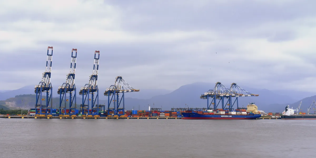
Ship-to-shore container cranes and a container ship alongside at the Port of Santos, with mountains behind under a cloudy sky.
Port call guide · São Paulo, Brazil

Port of Santos

The Port of Santos, on the Santos estuary in São Paulo State, is run by the Autoridade Portuária de Santos (APS), a federal state-owned company. Its 17 km of quays hold 64 berths serving 58 terminals, and in 2025 it handled 186.5 million tonnes of cargo, 5.9 million TEU and 5,772 ship calls.

23°57'24"S 46°18'37"W2

Photo: Porto de Santos (49871300568) by Enio Prado, CC BY-SA 2.0. Cropped and darkened by Costa Maritime; this version is CC BY-SA 2.0.

Port of Santos at a glance

Key facts for planning a call at the Port of Santos, with numbered sources
Port authority(Autoridade Portuária de Santos (APS))

Autoridade Portuária de Santos S.A. (APS), a federal state-owned company under the Ministry of Ports and Airports, is the port authority of the public port (Porto Organizado de Santos).1, 2, 3

portodesantos.com.br

Harbour master(Capitania dos Portos de São Paulo, NPCP-SP)

Capitania dos Portos de São Paulo (CPSP), the Brazilian Navy's harbour master for Santos. Its local rules are the NPCP-SP (Normas e Procedimentos da Capitania dos Portos de São Paulo), 3rd revision, Mod. 3, in force since 29 Sep 2026 (Portaria CPSP/ComOpNav/MB nº 196).4, 3, 5

Pilotage(Praticagem, Zona de Praticagem ZP-16)
  • Pilotage zone ZP-16 (Santos, Baixada Santista, São Sebastião and Tebar).
  • Federal law (Lei 9.537/1997, art. 13 § 6, as amended by Lei 14.813/2024) makes pilotage compulsory in every pilotage zone for vessels over 500 GT of any flag, except cases set by the Maritime Authority and Brazilian-flag inland craft.
  • At Santos the compulsory area runs between parallel 24°00'33"S and the ship's berth, and anchorage no. 4 lies outside it (NORMAM-311/DPC, Annex 4-A). Pilotage is compulsory there for pilotage navigation and for berthing, unberthing, shifting berth, mooring to or leaving buoys, anchoring and weighing anchor (Capitania rules, NPCP-SP 3rd revision Mod. 3, item 4.3.3).
  • Pilots: Praticagem de São Paulo (Santos Pilots), VHF channels 11 and 16.6, 3, 7, 8, 9
Maximum permissible draft(Calados operacionais (APS e CPSP))
  • As of 23 October 2026. Maximum operating drafts (calado máximo de operação), set by APS for each channel stretch under the coordination of the Maritime Authority, in its table 'Calados Operacionais dos Berços de Atracação', Revisão nº 271 of 30 Apr 2026.
  • Access channel, referred to Zero DHN (the DHN chart datum): Trechos I, II, III and IV, between the bar and Terminal Alamoa, 13.50 m at low water and 14.50 m at high water; Trecho IV-b, between Terminal Alamoa and the end of Trecho IV, 13.20 m at low water and 14.20 m at high water. The high-water values apply to any high tide of 1.00 m or more.
  • Deepest berths (BTP 01, 02 and 03, TECON 1.1, 1.2, 2 and 3, TEV, Outeirinhos 02, ARM 15, 16/17 and 19): 14.20 m at low water, 14.50 m at high water. Other berths are lower, for example Alamoa AL 01, AL 02 and AL 03 at 12.40 m at low water and 12.70 m at high water. Berth drafts are limited to the maximum operating draft of the channel stretch where the berth lies. Commercial ships berth at Outeirinhos 01 and 02 only with the prior agreement of the Maritime Authority. The maximum operating drafts may be changed because of wave height in the access channel.
  • The table covers public-port berths only. For private terminals in Trechos II, III and IV, Portaria CPSP nº 191/2026 (22 Sep 2026) sets operational drafts at low water (Zero DHN) and at high water: DP World berths DPW-1 13.8 m and 14.1 m, DPW-2 14.1 m and 14.4 m, DPW-3 14.0 m and 14.3 m, DPW-4 13.9 m and 14.2 m; Dow Química 9.7 m and 10 m; Cutrale 13.7 m and 14.0 m; São Paulo regasification terminal (TRSP) 12.2 m and 12.5 m.10, 3, 5, 11
Maximum vessel size(Comprimento (LOA) e boca)
  • As of 23 October 2026. Under the Capitania rules (NPCP-SP 3rd revision Mod. 3, item 5.8), two pilots are compulsory for cargo ships with LOA between 306 m and 340 m or with beam over 46 m, which are manoeuvred under special conditions with sea and wind up to Beaufort force 5 (winds under 21 knots), waves under 1.5 m and visibility over one nautical mile.
  • Container ships with LOA between 340 m and 370 m (New Panamax class) may have a beam of up to 52 m and a draft of up to 14.5 m; besides two pilots, they need wind up to Beaufort force 4 (15 knots), waves under 1.5 m with a period between 10 and 13 seconds, visibility over 1 nautical mile, an air draft of 67.5 m at most and a tidal current at the berth of up to 0.5 knot, and they manoeuvre at slack water (about up to 1 hour from high water) with no crossing of other ships on the stretch navigated, at up to 7 knots in the channel and 6 knots at the critical points; the turn at BTP is made in the turning basin with the ship at its smallest draft, and night manoeuvres are only experimental.
  • Under Portaria CPSP nº 155/2026 (16 Jul 2026), the design ship that may manoeuvre day and night, with visibility over 1 nautical mile and within the limits of each berth, has at most 306 m LOA and 46 m beam. For ships between 306 m and 340 m LOA or with beam over 46 m, the portaria repeats the two-pilot and weather conditions above and adds three more: ships drawing up to 13.70 m need waves under 1.80 m, with periods of up to 14 seconds, and a tide above 1.00 m over Zero DHN; these ships should preferably turn at their smallest draft, considering the berthing draft and the draft planned for unberthing; and their navigation, berthing and unberthing must respect the tide-rate limits set for each berth or terminal.
  • The total berthing space must be at least 110% of the LOA for ships up to 200 m and 115% above 200 m, with at least 15 m clear at each end (25 m for ships over 300 m). The AGEO berths take ships up to 80,000 DWT and 230 m LOA, and BTP ships up to 340 m LOA; New Panamax container ships between 340 m and 370 m LOA follow the separate conditions above (Portaria CPSP nº 154/2026). Berth lengths and drafts are in the APS draft table.3, 12, 13
Air draft(Calado aéreo (linhas de transmissão))
  • As of 23 October 2026. Power transmission lines (linhas de transmissão) in the Santos channel: ships with an air draft over 67.5 m may not proceed beyond the transmission towers in front of Armazém nº 25 in the access channel (Capitania rules, NPCP-SP 3rd revision Mod. 3, item 5.11 b).
  • APS gives 67.5 m above Zero DHN as the maximum air draft in practice for the berths and the channel upstream of berth Outeirinhos 3 (draft table, Revisão nº 271 of 30 Apr 2026).
  • The agent declares the ship's air draft when nominating the ship to APS.3, 10, 5
Tides(Tábua de marés (DHN, estação Porto de Santos))
  • Tide predictions: Brazilian Navy tide tables (tábua de marés, DHN), station Porto de Santos, 23°57.4'S 46°18.5'W, nautical chart 1711, mean level 0.78 m.
  • In the 2026 table the highest predicted high water is 1.51 m on 18 Feb 2026 (03:25 local time, UTC-3) and the lowest predicted low water is -0.13 m on 17 Feb 2026 (21:38). On most days (303 of the 365 days in 2026) the table predicts two high and two low waters of different heights.
  • The APS channel drafts are referred to Zero DHN, and the high-water drafts apply at any high tide of 1.00 m or more.14, 10, 15
Berths and terminals(Cais, berços e terminais)
  • 64 berths serving 58 terminals along 17 km of quays (APS, 2026).
  • Containers and general cargo: BTP, Santos Brasil, Ecoporto. Multipurpose: DP World Santos, Tiplam, Usiminas (TMPC). Vehicles: TEV.
  • Grain and sugar: ADM, Bunge, Copersucar (Teaçu), Cofco (TEC), TES, TGG, TEG and TEAG, T-Grão, Terminal XXXIX. Pulp: Bracell, Eldorado, Suzano, NST. Fertilisers: Hidrovias do Brasil, TERMAG.
  • Liquid bulk (fuels and chemicals) at Alamoa and Ilha Barnabé: Petrobras, Ultracargo, Vopak, Stolthaven, Ageo, Adonai, Granel Química, Dow. Citrus juice: Citrosuco, NST. Cruise terminal: Concais.2, 16, 17
Clearance authorities(Receita Federal, Anvisa, Polícia Federal e Vigiagro)
  • Customs: Alfândega da Receita Federal do Brasil no Porto de Santos (ALF Porto de Santos).
  • Health: Anvisa, Posto de Santos, grants free pratique (Certificado de Livre Prática), requested through Porto Sem Papel and issued within 72 hours at most; anchorage no. 6 is the quarantine anchorage.
  • Immigration: Polícia Federal, which acts as maritime police; its maritime unit (Nepom) inspects international traffic on ships at the port.
  • Launches working for the owner or agent may not go alongside an anchored ship arriving from a foreign port before Receita Federal, Polícia Federal and Anvisa clear it.
  • Agriculture: Vigiagro (MAPA), Serviço de Vigilância Agropecuária Internacional de Santos, in the Alfândega building.18, 19, 20, 4, 21, 22, 3
Crew change airport(Aeroporto Internacional de São Paulo/Guarulhos)
  • São Paulo/Guarulhos International Airport (GRU), Governador André Franco Montoro, an international airport (DECEA category AD INTL).
  • About 92 km by road from the port, about 1 h 35 min without traffic (approximate route on OpenStreetMap data between the APS port position and the GRU aerodrome reference point).23, 24, 25
Dredged depth and access channel(Canal de navegação)
  • Access channel 15 m deep and 220 m wide at its narrowest stretch (Capitania, NPCP-SP item 1.2.1).
  • Deepening to 16 m started on 17 Jul 2026 with the environmental studies for licensing; APS expects this first phase to take up to 21 months.3, 26, 27, 2
Anchorages(Fundeadouros)
  • Six anchorages, defined in the Capitania rules (NPCP-SP) and shown on the nautical chart; anchoring outside them is prohibited, and stays are limited to 30 days, with exceptions decided by the Capitania.
  • No. 1 warships only; no. 2 sanitary inspection or clearance (crew embarking or landing, workshops, materials), stay of 3 hours at most; no. 3 ships with a berthing slot in the next 24 hours; no. 4 ships with or without a berthing schedule; no. 5 ships with flammable or explosive cargo; no. 6 ships in quarantine and ships with suspected damage to packages or leaks of radioactive material.
  • Anchorages are used only as programmed by APS. Any anchored vessel keeps at least 30 m from berthed ships, and its swinging circle may not enter the navigation channel. VHF and AIS must stay working while at anchor.3, 21, 5
Restrictions(Restrições às manobras)
  • As of 23 October 2026. Age: ships over 30 years old without documented retrofit are not accepted at Santos; ships over 18 years old must present P&I cover with a wreck-removal clause to APS and may be inspected (PSC or FSC) at the Maritime Authority's discretion (APS NAP.SUPOP.021.2026 of 22 Sep 2026, art. 38).
  • Trim: the APS draft table (Revisão nº 271) sets a minimum forward draft, a maximum stern trim and a minimum propeller immersion by DWT.
  • Channel (Capitania rules, NPCP-SP 3rd revision Mod. 3): maximum speed 9 knots over the ground; no overtaking anywhere in the Baixada Santista estuary except in special situations agreed by the master of the ship being overtaken and the pilots on board; no crossing of ships of any size near the ferry crossing; between Ilha das Palmas and the mouth of the Rio do Meio, no crossing if either ship is over 230 m LOA or over 11.50 m draft, or is a passenger ship, a Ro-Ro ship, a warship (except patrol ships and ships under 80 m), a ship carrying explosive or radioactive cargo or a ship with engine or rudder restrictions; between armazéns 29 and 12A, no crossing if the two ships' LOAs add up to more than 460 m, if either ship is over 280 m LOA or over 11.50 m draft, or if either is of a type barred in the previous stretch; the Piaçaguera channel takes one ship at a time, and no ships cross anywhere in the estuary in low visibility.
  • Ships carrying explosive or radioactive cargo (some cargoes exempt) must report it 72 hours before entry or departure, may not cross other ships anywhere in the estuary and access channel, and manoeuvre by day only; Portaria CPSP nº 155/2026, of July, gives 48 hours for that notice and also exempts IMDG subgroup 1.3 explosives; planning for the 72-hour notice meets both.
  • Ships without two anchors and two windlasses in normal working order enter and leave by day only, with at least two tugs made fast in the channel.
  • Under Portaria CPSP nº 155/2026, ships up to 306 m LOA and 46 m beam manoeuvre day and night with visibility over 1 nautical mile, within the limits of each berth. Berthing, unberthing and turning at many berths are limited to periods when the tide rises or falls slowly enough, at rates set for each berth, ship size and draft; slack water is any period when the tide changes by less than 0.10 m per hour, and at slack water manoeuvres may be made at any berth or terminal, subject to the other restrictions not related to current strength. The slack-water windows may be widened or narrowed locally, on the basis of the channel sensors and information from the Santos pilots.
  • The same portaria sets 9 knots between Fortaleza da Barra and Terminal Alamoa, 6 knots in the Piaçaguera channel between Alamoa and the Usiminas and Tiplam terminals, and 12 knots in the outer channel between buoy no. 6 and the limit of the pilotage zone.5, 10, 3, 12
Tugs(Rebocadores)
  • As of 23 October 2026. Two tugs made fast are recommended for ships over 10,000 GT berthing at oil, oil product and chemical terminals, whatever thrusters they have. Ships carrying explosive or radioactive cargo (some cargoes exempt) navigate the whole estuary and channel with at least one azimuth tug made fast at the stern.
  • Container ships with LOA between 340 m and 370 m (New Panamax class) need two main azimuth tugs, one of at least 70 t bollard pull made fast at the centre of the stern and one of at least 60 t, connected at buoy no. 5 inbound and kept until buoy no. 4 outbound; the other support tugs accompany the ship between buoy no. 8 and the berth, and experimental night manoeuvres need one more standby tug of at least 60 t. (Capitania rules, NPCP-SP 3rd revision Mod. 3, items 4.1.4, 4.2.2, 4.2.5, 5.8 and 5.26.)
  • Minimum numbers by ship size are in Portaria CPSP nº 155/2026 (16 Jul 2026) and its annex table, with azimuth or tractor tugs of at least 40 t bollard pull unless stated: ships under 225 m LOA and 60,000 DWT, 2 tugs for any manoeuvre; between 225 m and 280 m LOA or between 60,000 and 85,000 DWT, 2 tugs, with none, one or two of 60 t depending on draft, turning and berth (two of 60 t at Valongo and Alamoa in direct manoeuvres at 12.00 m draft or more and at DPW and BTP when turning at 11.50 m or more; at the other berths named in the table, turning at 11.50 m or more takes two tugs of 60 t or three tugs with one of 60 t); between 280 m and 306 m LOA or between 85,000 and 100,000 DWT, 2 or 3 tugs with at least one or two of 60 t, depending on draft, turning and berth; between 306 m and 340 m LOA, beam over 46 m or between 100,000 and 135,000 DWT, between 2 and 4 tugs with at least one or two of 60 t, depending on draft, turning and berth (no figures for Usiminas and Tiplam); between 340 m and 370 m LOA, beam over 50 m or between 135,000 and 160,000 DWT, 4 tugs (two of 70 t and two of 60 t), with figures only for DPW, BTP and the berths the table does not name.
  • The master and pilot may agree to use more tugs than the table requires. In the two smallest classes (under 280 m LOA and 85,000 DWT) they may also agree to drop one tug, except at Valongo and Alamoa. If the ship's bow or stern thrusters have a total power of at least 3,000 HP, the master and pilot may agree to drop one tug in direct manoeuvres in the class between 280 m and 306 m LOA (not at Valongo and Alamoa), or the third and least powerful tug when a ship of that class turns; in the class between 306 m and 340 m LOA, they may drop the third and least powerful tug in the same way if the thrusters total at least 4,000 HP.
  • Tugs must be made fast, with no waiver, between Fortaleza da Barra and the berth for ships with propulsion or steering incidents in the last 90 days or 5 calls in ZP-16, ships with known deficiencies such as a missing anchor or propulsion or steering problems, ships 18 years old or more, ships drawing 13.50 m or more or of 95,000 DWT or more, ships between 306 m and 340 m LOA or with beam over 46 m (an azimuth tug of at least 60 t made fast at the stern at buoy no. 4 inbound and kept until buoy no. 4 outbound) and ships with dangerous or polluting cargo under the IMDG Code, such as gas carriers, ships with ammonia or explosive or radioactive cargo, and loaded or non-inert tankers and chemical carriers; these ships take at least two tugs for berthing and unberthing, and that minimum may not be reduced.
  • Passenger ships must be accompanied by at least one tug along the channel, not necessarily made fast.3, 12
Pilot boarding(Ponto de embarque de prático)
  • Pilot boarding and landing point for the Santos and Baixada Santista port complexes: 24°00'33"S 046°20'12"W, with buoy 1A as visual reference (Capitania rules, NPCP-SP 3rd revision Mod. 3, item 4.3.3 h).
  • For container ships with LOA between 340 m and 370 m, the two pilots board 1 nautical mile south of buoy 1A (item 5.8 b).
  • If boarding or landing at the boarding point is unsafe, the Capitania may declare indirect pilotage (amber condition, item 4.3.7): the master decides beforehand, through the agent, whether to wait for normal pilotage or to take the ship in, under the master's sole responsibility and following the pilot's signals from the pilot launch, to a sheltered spot between Fortaleza da Barra and buoy no. 6 of the access channel, where the pilot boards; outbound, the pilot lands in the same area.
  • Pilots are requested from the Santos pilot station (Estação de Praticagem de Santos), which keeps watch on VHF channels 11 and 16. The pilots ask for the request no more than 12 hours and no less than 6 hours before the planned manoeuvre, and by 18:00 the day before for manoeuvres starting between 00:30 and 07:30; the request must state the ship's draft.
  • The agent also requests each entry, departure and shift from APS through its Supervia system.3, 28, 5
Weather limits(Condições de praticabilidade (ondas, vento e visibilidade))
  • As of 23 October 2026. Traffic in the Santos port complex is suspended in full (red condition) when waves exceed 3.0 m, sustained wind exceeds 30 knots or gusts exceed 35 knots, or visibility is under 0.5 nautical mile.
  • It is suspended partially (amber condition): for ships over 306 m LOA when waves are over 1.5 m and under 3 m; for ships over 306 m LOA and ships with a large wind area, such as Ro-Ro ships or ships in ballast, when sustained wind is over 17 and under 30 knots or gusts are over 25 and under 35 knots; and for ships over 306 m LOA and ships with any obstruction of the line of sight between bridge and bow when visibility is under 1 nautical mile. The Capitania declares the condition (Capitania rules, NPCP-SP 3rd revision Mod. 3, items 4.3.7 and 5.7.1).
  • Under item 4.3.7 the amber condition is also indirect pilotage, described under pilot boarding; the Capitania's practicability table for Santos lists waves of 1.2 m or more with a period under 8 seconds, or wind over 12 knots, for this condition.
  • When heavy rain in the Serra do Mar or ocean currents make tidal streams stronger than, or different from, the predictions, the pilots advise the Capitania, which may change restrictions temporarily.
  • Fog: in August 2024 navigation was suspended for 116 hours because of fog (APS). Prevailing winds are E-NE; APS also lists NW winds of 20 knots and SW winds of 28 knots.3, 29, 2
Bunkers, fresh water and waste reception(Combustível, água e resíduos)

The liquid bulk terminals at Alamoa and Ilha Barnabé also supply bunkers to ships. Fuel supply to ships, potable water and ship waste removal are provided by companies accredited by APS under its port rules.2, 30, 31, 32

Line-up(Programação de navios (line-up))

APS publishes the ship line-up (Navegação e Movimento de Navios): expected ships, scheduled berthings, ships alongside and ships at anchor, also in English as the Ship Tracker.33, 34

APS Ship Tracker: Port of Santos

Main cargo and throughput(Movimentação de cargas)

2025: 186.5 million tonnes, 5.9 million TEU and 5,772 ship calls (APS). APS figures include private terminals (TUPs) and on-board consumption. Main cargoes: containers, soy, sugar, corn, pulp, fertilisers, fuels and chemicals.2, 35

For planning reference only, not for navigation. Drafts depend on tide, under-keel clearance, ship type and the current port authority and Capitania dos Portos rules; the pilots and the Capitania have the final word. Confirm before fixing the vessel. Our operations desk can obtain the current figure from the pilots.

Planning a call at Santos

  • APS sets drafts against Zero DHN: 13.50 m at low water and 14.50 m at high water (any high tide of 1.00 m or more) in the access channel up to Terminal Alamoa, and each berth is limited by its channel stretch.
  • Ships up to 306 m LOA and 46 m beam manoeuvre day and night; larger ships need two pilots and calmer weather, New Panamax container ships follow Portaria CPSP nº 154/2026, and power lines in front of Armazém nº 25 limit the air draft to 67.5 m.
  • Minimum tugs follow the Portaria CPSP nº 155/2026 table, and ships 18 years old or more, drawing 13.50 m or more or carrying dangerous cargo keep tugs made fast between Fortaleza da Barra and the berth.
  • All traffic stops with waves over 3.0 m, wind over 30 knots (gusts over 35) or visibility under 0.5 nautical mile, and fog suspended navigation for 116 hours in August 2024.

Before arrival, your agent nominates the ship to APS with its air draft and requests each entry, departure and shift through the Supervia system, requests free pratique (CLP) from Anvisa through Porto Sem Papel, and books the pilots between 12 and 6 hours before the manoeuvre.

Port of Santos: frequently asked questions

What is the maximum draft at the Port of Santos?

APS sets the drafts against Zero DHN: 13.50 m at low water and 14.50 m at high water in the access channel up to Terminal Alamoa, with 14.20 m and 14.50 m at the deepest berths, such as BTP and TECON, within the channel limit. Private terminals follow Portaria CPSP nº 191/2026.

How many tugs does a ship need at the Port of Santos?

Portaria CPSP nº 155/2026 sets the minimum by LOA, DWT, berth and draft: 2 tugs for ships under 225 m LOA and 60,000 DWT, and 4 (two of 70 t and two of 60 t) for New Panamax container ships between 340 m and 370 m LOA.

When does the Port of Santos stop traffic for weather?

All traffic stops (red condition) with waves over 3.0 m, sustained wind over 30 knots, gusts over 35 knots or visibility under 0.5 nautical mile. Ships over 306 m LOA stop earlier (amber condition), with waves over 1.5 m, sustained wind over 17 knots, gusts over 25 knots or visibility under 1 nautical mile.

Where do ships anchor off the Port of Santos?

In six anchorages set by the Capitania and used as programmed by APS, with stays of up to 30 days: no. 3 for ships berthing within 24 hours, no. 4 for ships with or without a berthing schedule, no. 5 for flammable or explosive cargo and no. 6 for quarantine.

Working with Costa Maritime at Santos

At Santos, a vetted local partner attends the vessel on our behalf. You deal only with Costa Maritime: we prepare your PDA and FDA and remain your single point of contact.

Proforma disbursement account (PDA)

Send the vessel type, GT and NT, LOA, beam and drafts, the purpose of the call, the cargo and the expected days in port, and we prepare your proforma disbursement account.

Request a PDA for Santos

The PDA is an estimate based on the particulars you send and the tariffs and exchange rate in force; the final disbursement account (FDA) reflects the actual call.

Sources

  1. A Companhia, Santos Port Authority (APS). Accessed 21 October 2026.
  2. Facts & Figures 2026 / Fatos e Dados 2026, Santos Port Authority (APS), 2026. Accessed 21 October 2026.
  3. NPCP-SP, 3ª Revisão, Mod. 3 (Portaria CPSP nº 196, de 29 de setembro de 2026), Capitania dos Portos de São Paulo (CPSP), 29 September 2026. Accessed 23 October 2026.
  4. Agentes que atuam no Porto, Santos Port Authority (APS). Accessed 21 October 2026.
  5. NAP.SUPOP.021.2026, Normas para Atracação de Navios no Porto de Santos (art. 38), Santos Port Authority (APS), 22 September 2026. Accessed 21 October 2026.
  6. Lei nº 14.813, de 15 de janeiro de 2024, republicação (DOU Seção 1, 17/01/2024, p. 1), Câmara dos Deputados, Legislação Informatizada (reproduction of the DOU text), 17 January 2024. Accessed 21 October 2026.
  7. Zonas de Praticagem: ZP 16, Santos, Baixada Santista, São Sebastião e Tebar (SP), Praticagem do Brasil (Conselho Nacional de Praticagem). Accessed 21 October 2026.
  8. Santos Pilots, Praticagem de São Paulo, Praticagem de São Paulo. Accessed 21 October 2026.
  9. NORMAM-311/DPC, Normas da Autoridade Marítima para o Serviço de Praticagem (2026, Mod. 5), Marinha do Brasil, Diretoria de Portos e Costas (DPC), 21 September 2026. Accessed 23 October 2026.
  10. Calados Operacionais dos Berços de Atracação, Revisão nº 271, Santos Port Authority (APS), 30 April 2026. Accessed 21 October 2026.
  11. Portaria nº 191/CPSP, de 22 de setembro de 2026, Capitania dos Portos de São Paulo (CPSP), 22 September 2026. Accessed 23 October 2026.
  12. Portaria nº 155/CPSP, de 16 de julho de 2026 (arquivo compactado com o PDF), Capitania dos Portos de São Paulo (CPSP), 16 July 2026. Accessed 23 October 2026.
  13. Portaria nº 154/CPSP, de 16 de julho de 2026, Capitania dos Portos de São Paulo (CPSP), 16 July 2026. Accessed 23 October 2026.
  14. Meteorologia e Marés, Santos Port Authority (APS). Accessed 21 October 2026.
  15. Tábuas das Marés 2026: 46 - Porto de Santos (Estado de São Paulo), pp. 148 to 150, Marinha do Brasil, Diretoria de Hidrografia e Navegação (DHN), 2026. Accessed 23 October 2026.
  16. Panorama (terminals by cargo type), Santos Port Authority (APS). Accessed 21 October 2026.
  17. Berços de Atracação, Santos Port Authority (APS). Accessed 21 October 2026.
  18. Quem é Quem: Alfândegas, São Paulo, Receita Federal do Brasil. Accessed 21 October 2026.
  19. Mapa: São Paulo (Posto de Santos), Anvisa, 9 July 2025. Accessed 21 October 2026.
  20. Solicitar Certificado de Livre Prática, Anvisa (gov.br service page), 15 December 2025 (last modified). Accessed 21 October 2026.
  21. Áreas de Fundeio, Santos Port Authority (APS). Accessed 21 October 2026.
  22. DIGRV-SE, Divisão de Gestão Regional do Vigiagro Sudeste, Ministério da Agricultura e Pecuária (MAPA), 17 July 2026 (updated). Accessed 21 October 2026.
  23. AISWEB ROTAER: SBGR Guarulhos - Governador André Franco Montoro, DECEA (Departamento de Controle do Espaço Aéreo), D-AMDT 26/26. Accessed 21 October 2026.
  24. GRU Airport - Aeroporto Internacional de São Paulo - Site Oficial, GRU Airport (airport operator). Accessed 21 October 2026.
  25. OSRM public routing API (OpenStreetMap data), Project OSRM, computed 21 October 2026. Accessed 21 October 2026.
  26. Dragagem, Santos Port Authority (APS). Accessed 21 October 2026.
  27. APS dá início ao projeto de dragagem de aprofundamento do canal de navegação do Porto de Santos, Santos Port Authority (APS), 20 July 2026. Accessed 21 October 2026.
  28. Condições de Atendimento, Praticagem de São Paulo. Accessed 21 October 2026.
  29. Mesmo com neblina em agosto, Porto de Santos quebra novo recorde de movimentação de cargas, Santos Port Authority (APS), 24 September 2024. Accessed 21 October 2026.
  30. Credenciamento de Serviços de Interesse Ambiental e Segurança do Trabalho, Santos Port Authority (APS). Accessed 21 October 2026.
  31. Abastecimento de Água Potável, Santos Port Authority (APS). Accessed 21 October 2026.
  32. Normas e regulamentos operacionais, Santos Port Authority (APS). Accessed 21 October 2026.
  33. Navegação e Movimento de Navios, Santos Port Authority (APS). Accessed 21 October 2026.
  34. Ship Tracker, Santos Port Authority (APS). Accessed 21 October 2026.
  35. Estatísticas, Santos Port Authority (APS). Accessed 21 October 2026.

Last reviewed: October 2026

Planning a call at Santos?

Send the vessel particulars and the dates. We prepare the PDA and coordinate the call with one point of contact.