Costa Maritime

Brasil --:-- · 24/7
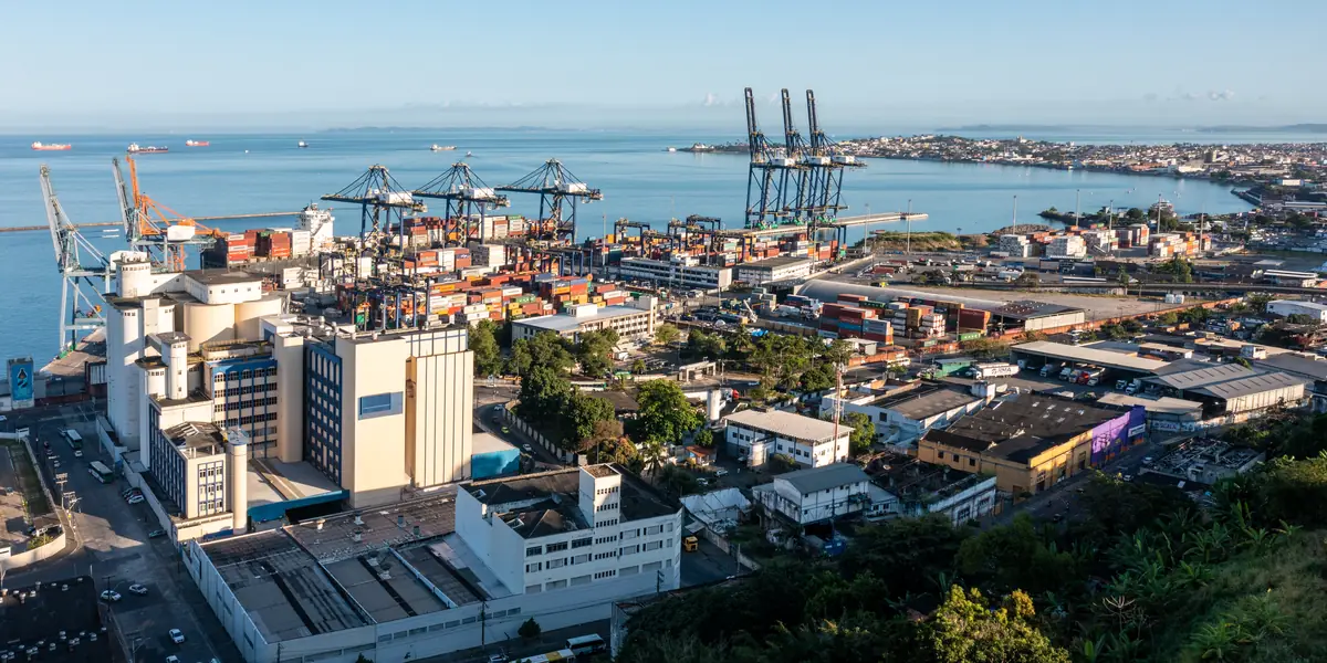
Aerial view of the Port of Salvador: the TECON Salvador container terminal with its ship-to-shore cranes and container yard, silos beside the quay and ships at anchor in Todos os Santos Bay.
Port call guide · Bahia, Brazil

Port of Salvador

The Port of Salvador, in the city's Comércio district on Todos os Santos Bay, is run by CODEBA, with its container terminal operated by Wilson Sons as TECON Salvador. It handled 7.0 million tonnes and 466 ship calls in 2025, mainly containers, general cargo, wheat, pulp and fruit, and berth 201 serves cruise ships. Aratu-Candeias, CODEBA's bulk port in the same bay, is covered further down this page.

12°58'00"S 038°31'00"W21

Photo: Porto de Salvador Bahia Vista Aérea 2021-0005 by Paul R. Burley, CC0. Cropped and darkened by Costa Maritime.

Port of Salvador at a glance

Key facts for planning a call at the Port of Salvador, with numbered sources
Port authority(Autoridade Portuária (CODEBA))

Companhia das Docas do Estado da Bahia (CODEBA), the port authority, owns, administers and operates the port, except the container terminal, which Wilson Sons operates as TECON Salvador.1, 2

codeba.gov.br

Harbour master(Capitania dos Portos da Bahia)

Capitania dos Portos da Bahia (CPBA), Brazilian Navy, Avenida das Naus s/n, Comércio, Salvador. Its jurisdiction covers the waters of the whole Bahia coast, including Todos os Santos Bay.1

Pilotage(Praticagem, Zona de Praticagem ZP-12)
  • Compulsory. Pilotage zone ZP-12 covers Salvador, the ports and terminals of Todos os Santos Bay, and Ilhéus.
  • By law (Lei 9.537/1997, art. 13, § 6, inserted by Lei 14.813/2024), pilotage is compulsory in every pilotage zone for ships over 500 GT, save exemptions set by the Maritime Authority and Brazilian-flag inland craft.
  • NPCP-BA/2024 item 4.13.2 makes it compulsory for Brazilian and foreign ships at all ports and terminals in the CPBA area for berthing, unberthing, anchoring and weighing anchor, except cases in NORMAM-311/DPC.
  • NORMAM-311/DPC (Anexos 4-A and 4-D, as amended to 21 Sep 2026) makes pilotage compulsory for anchoring in inner anchorage areas I, II, III, IV and VI and for weighing anchor in areas IV and VI, and optional, with no exception listed, for ships of any gross tonnage that weigh anchor in inner areas I, II and III to leave the bay.
  • NPCP-BA/2024 words this optional case as weighing anchor south of the line between the Farolete Norte of the north breakwater and Farolete Mar Grande, outbound for the bay entrance, and keeps a pilot compulsory there for ships with a draft of 18 m or more; confirm with the ZP-12 Operations Centre before weighing anchor without a pilot.
  • Five pilot companies serve ZP-12: Bahia Pilots, Madre de Deus Pilots, Salvador Pilots, BTS Pilots and Ilhéus Pilots.
  • Pilotage is coordinated by the ZP-12 Operations Centre, run by Bahia Pilots. As of NPCP-BA/2024, 1st revision (file dated Feb 2025), and NORMAM-311/DPC as amended to 21 Sep 2026.1, 3, 4
Maximum permissible draft(Calado Máximo Recomendado (CMR), NPCP-BA/2024)
  • No fixed figure is published. The Recommended Maximum Draft (CMR) is calculated per berth: CMR = (P + M) - [(P + M) x FS], where P is the local depth reduced to chart datum (nível de redução), M is the tide height at the time per the tide table, and FS is the safety factor: 11.6% for berths 610 and 611; 8% for berths 201, 202, 203, 204, 205 and 300.
  • At the container terminal (TECON), the ReDRAFT under-keel clearance system may be used under NORMAM-224/DPC, only for ships covered by the evaluation and test runs (L ≤ 366 m, B ≤ 52 m) and with a manoeuvrability margin of 1.0 m or 5% of draft, whichever is greater; if the system fails, the static rule applies.
  • Minimum under-keel clearance at berth 611: 0.5 m.
  • The CMR is not an operational limit in transit, but disregarding it is taken into account when judging any maritime accident.
  • As of 22 October 2026 (NPCP-BA/2024, 1st revision, file dated February 2025).1, 5
Maximum vessel size(Restrições de porte (TPB, LOA, boca))
  • As of 22 October 2026 (NPCP-BA/2024, 1st revision, file dated February 2025), by berth: 610 Cais Santa Dulce: LOA 366 m, 200,000 dwt (displacement 253,000 t).
  • 611 container quay (TECON): LOA 366.0 m, beam 52.0 m, 136,000 dwt (displacement 170,000 t).
  • 300 Cais de Ligação: 65,000 dwt (84,000 t).
  • 202: 50,000 dwt (60,000 t).
  • 201, 203, 204 and 205: 40,000 dwt (50,000 t).
  • No LOA or beam limit is published for the other berths.1
Tides(Tábua de marés (DHN, Porto de Salvador))
  • Semidiurnal: two high and two low waters a day.
  • DHN reference station Porto de Salvador (12°58.4'S 038°31'W, chart 1102), mean level 1.34 m.
  • In the DHN 2026 predictions heights lie between -0.07 m and 2.74 m; on 19 March 2026, for example, the predicted high waters are 2.59 m and 2.74 m and the low waters 0.13 m and 0.03 m.6
Berths and terminals(Berços, Cais Comercial e TECON Salvador)
  • 2,269 m of quay: 800 m form the TECON Salvador container terminal and 1,469 m the public commercial quay (CODEBA port rules, Rev. 03, Aug 2025).
  • Eight berths (NPCP-BA/2024): 201 in front of the passenger terminal (383.60 m of quay), 202 at warehouses 3 and 4 (300 m), 203 at warehouses 5 and 6 (225 m), 204 at warehouses 6, 7, 8 and 9 (225 m), 205 Cais de Carvão (516 m), 300 Cais de Ligação (230 m in NPCP-BA, 240 m in CODEBA's rules), 611 container quay, which CODEBA calls Cais de Água de Meninos (377 m), and 610 Cais Santa Dulce (423 m).
  • Wilson Sons operates berths 300, 610 and 611, which are preferential for full-container ships handled through TECON Salvador.
  • Berth 201 has priority for cruise ships.
  • Main cargoes: containers, general cargo, wheat, pulp and fruit, plus cruise passengers.5, 1, 2
Clearance authorities(Receita Federal, ANVISA, Polícia Federal e VIGIAGRO)
  • Customs: Alfândega da Receita Federal do Brasil em Salvador (ALF/SDR), the customs authority for the Salvador and Aratu-Candeias public ports.
  • Health: ANVISA, Bahia port and border coordination (CVPAF-BA), grants free pratique (Certificado de Livre Prática, RDC 72/2009); quarantine anchorage is Área IV, a 0.25 NM circle centred 12°55.04'S 038°35.82'W, designated by the Maritime Authority.
  • Immigration and crew changes: Polícia Federal, port unit at Av. da França, Comércio (24 h), and the immigration office (DELEMIG) at Salvador airport.
  • Agriculture: VIGIAGRO/MAPA, Serviço de Vigilância Agropecuária Internacional de Salvador (SEV-SVD), Av. da França 1551.7, 5, 8, 9, 1, 10, 11
Crew change airport(Aeroporto Internacional de Salvador)
  • Salvador Bahia Airport (Deputado Luís Eduardo Magalhães), IATA SSA, ICAO SBSV.
  • International airport with direct flights to Lisbon, Madrid, Paris, Panama City, Buenos Aires, Montevideo and Santiago (airport's destination list).
  • About 26.8 km by road to the port at Av. da França, roughly 32 min without traffic (approximate route on OpenStreetMap data; peak hours take longer).12, 13, 14, 15
Dredged depth and access channel(Profundidade dos berços (carta DHN 1102))
  • No dredged depth for the access channels is published in the NPCP-BA/2024 Salvador appendix.
  • Berth depths (NPCP-BA/2024): 201: 8 m; 202: 11.50 m; 203: 8.0 m, or 9.4 m with the floating fender; 204 and 205: 8.0 m, or 9.80 m with the floating fender; 300: 12 m; 610 and 611: 16 m.
  • For berth 204 with the floating fender, CODEBA's port rules (Rev. 03, Aug 2025) give 9.4 m; confirm with the agent.
  • Depths in the 700 m wide manoeuvring strip along the quay vary between 8 and 12 m per DHN chart 1102.1, 5
Anchorages(Áreas de fundeio da Baía de Todos os Santos)
  • Todos os Santos Bay anchorages (NPCP-BA/2024 item 5.6), administered by the Salvador port authority:
  • Áreas I and II for bunkering, surveys, small repairs, stores and crew, for ships with draft of 10 m or less and LOA of 200 m or less;
  • Área III for anchoring and the same services, ships over 10 m draft or over 200 m LOA;
  • Área IV quarantine;
  • Área V free anchorage for ships waiting for an inner anchorage (35 ships);
  • Área VI LNG carriers for the Bahia regasification terminal (TRBA);
  • Área VII yachts of 60 m and over;
  • Áreas VIII, IX and X ship-to-ship and transshipment authorized by the CPBA.
  • Ships may stay up to 10 days in Áreas I, II and III, then must spend at least 24 h in Área V.
  • No anchoring in the channel between Áreas II and III, within 500 m of the pilot boarding point, or in the bay approach between latitudes 12°59.5'S and 13°05.0'S except in Área V.
  • As of 22 October 2026 (NPCP-BA/2024, 1st revision, file dated February 2025).1
Restrictions(Restrições de manobra e de tráfego)
  • As of 22 October 2026 (NPCP-BA/2024, 1st revision, file dated February 2025, and later Capitania acts), there is no time-of-day restriction at Salvador.
  • Berthing and unberthing limited to wind up to 20 kn.
  • Ships may not cross each other at the north and south entrances (barras Norte and Sul); the outbound ship has priority.
  • No crossing in the curved section or in the approach channel to the turning basin; both are one-way, with no overtaking.
  • Speed limits: 8 kn on the straight section, 7 kn on the curved section, 6 kn in the approach channel.
  • TECON: ships of LOA between 299 and 305 m berth port side to when the wind is between 15 and 20 kn.
  • At any berth in the port, ships over 305 m LOA always berth port side to.
  • Ships of LOA 299 m or more with a beam over 42 m need two pilots at TECON, and the NPCP table sets: wind under 15 kn, 3 tugs of at least 40 t bollard pull each and 130 t in total, either side to; wind between 15 and 20 kn, manoeuvre without turning; wind over 20 kn, no manoeuvre.
  • Platforms berth and unberth in Todos os Santos Bay in daylight only.
  • No age restriction found.
  • Under Portaria CPBA nº 36/2026 of 3 September 2026, traffic is also restricted inside the waters marked by yellow special buoys around the work areas of the temporary linear platform (Plataforma Linear Provisória) and the Salvador-Itaparica bridge in Todos os Santos Bay: only vessels involved in carrying out, supporting or inspecting the works may enter or remain there, and the restriction does not apply to state vessels, vessels on search and rescue operations or vessels responding to emergencies.1, 16
Tugs(Rebocadores)
  • Tugs are compulsory for every berthing and unberthing at all ports and terminals in Todos os Santos Bay.
  • Minimum at Salvador by LOA, all azimuth tugs over 40 t bollard pull: 200 m or less, 1; between 201 and 299 m, 2; between 300 and 333 m, 3; between 334 and 366 m, 4.
  • For a ship between 300 and 333 m berthed starboard side to at the container quay, the unberthing minimum may be reduced to 2.
  • Ships of LOA 299 m or more with a beam over 42 m at TECON follow the wind and tug table under restrictions. As of 22 October 2026 (NPCP-BA/2024, 1st revision, file dated February 2025).1
Pilot boarding(Ponto de Espera de Prático (PEP))
  • Pilot boarding point (PEP) at 13°00.78'S 038°33.74'W (decimal -13.0130, -38.5623), at the bay entrance; no anchoring within 500 m of it.
  • Ships waiting for the pilot hoist the pilot call signal of the International Code of Signals, at anchor or under way, and the pilot boards only after the master authorizes it by radio.
  • NPCP-BA/2024 sets no advance notice for the pilot request; pilotage is coordinated by the ZP-12 Operations Centre (see pilotage).1
Weather limits(Impraticabilidade da barra)
  • Bar impracticability thresholds for Todos os Santos Bay (Portaria CPBA nº 21/2025, which replaced NPCP-BA item 4.17).
  • Green, full practicability: significant wave height Hs ≤ 2.0 m, wind ≤ 17 kn and visibility ≥ 1.0 NM.
  • Amber, values between green and red: the Harbour Master may declare total or partial impracticability.
  • Red: Hs ≥ 2.5 m, wind ≥ 30 kn or visibility ≤ 0.5 NM; the pilots must contact the CPBA so the Harbour Master can decide.
  • The limits also apply to ships exempt from pilotage.
  • Berthing and unberthing at Salvador: wind up to 20 kn (NPCP-BA/2024).17, 1
Bunkers, fresh water and waste reception(Combustível, água e resíduos)
  • Bunkering at berth follows CODEBA's ship bunkering norm (Norma de Acompanhamento do Abastecimento de Navios, 15 April 2003): the agent notifies CODEBA by email at least 24 h ahead, and containment booms must be in place before pumping starts.
  • Fresh water: hydrants at berths 201, 202, 203, 204 and 205; berths 300, 610 and 611 (Wilson Sons) have none.
  • Water requests go to CODEBA's Salvador programming desk.
  • The port does not supply electricity to ships.
  • Ship waste is collected only by companies registered with the port authority.5
Line-up(Programação de navios (line-up))

CODEBA publishes the Salvador line-up of expected and berthed ships.18

CODEBA line-up: Port of Salvador

Main cargo and throughput(Movimentação de cargas)
  • 2025: 7,008,636 t and 466 ship calls.
  • In the first eight months of 2026: 5,064,610 t, 14.15% above the same period of 2025.19, 20

For planning reference only, not for navigation. Drafts depend on tide, under-keel clearance, ship type and the current port authority and Capitania dos Portos rules; the pilots and the Capitania have the final word. Confirm before fixing the vessel. Our operations desk can obtain the current figure from the pilots.

Planning a call at Salvador

  • There is no fixed maximum draft: the CMR is calculated per berth from the depth, the tide at the time and a safety factor (8% at berths 201, 202, 203, 204, 205 and 300; 11.6% at 610 and 611), so ask the pilots for the figure for your berth and tide.
  • Container ships of up to 366 m LOA and 52 m beam berth at TECON; ships of 299 m or more with a beam over 42 m need two pilots and three tugs there, and no manoeuvre takes place with wind over 20 knots.
  • Ships may not cross at the north and south entrances, where the outbound ship has priority, and the curved section and the approach channel are one-way, with speed limits of 8, 7 and 6 knots.
  • Ships may stay up to 10 days in anchorage Areas I, II and III, then must spend at least 24 hours in Area V; Area IV is the quarantine anchorage.
  • Portaria CPBA nº 36/2026, of 3 September 2026, closes the waters around the works for the Salvador-Itaparica bridge, marked by yellow buoys, to vessels not involved in the works.

Before arrival, your agent requests free pratique from ANVISA (CVPAF-BA) and notifies CODEBA by e-mail at least 24 hours before any bunkering at berth; pilotage is arranged through the ZP-12 Operations Centre, run by Bahia Pilots.

Nearby port: Aratu-Candeias

Aratu-Candeias is a separate organised port in Todos os Santos Bay, also run by CODEBA, with terminals for solid bulk (TGS), liquid bulk (TGL) and gas (TPG). It handled 5.8 million tonnes in 2025 and shares pilotage zone ZP-12, its rules and the pilot boarding point with Salvador.

12°47'00"S 038°30'00"W24

Key facts for planning a call at Aratu-Candeias, with numbered sources
Port authority(Autoridade Portuária (CODEBA))

Companhia das Docas do Estado da Bahia (CODEBA), which also runs Salvador and Ilhéus.5, 1

codeba.gov.br

Pilotage(Praticagem, Zona de Praticagem ZP-12)

Compulsory. Same pilotage zone (ZP-12), rules and pilot boarding point (13°00.78'S 038°33.74'W) as Salvador. Pilotage is coordinated by the ZP-12 Operations Centre, run by Bahia Pilots.1, 4

Maximum permissible draft(Calado Máximo Recomendado (CMR), NPCP-BA/2024)
  • No fixed figure is published (as of 22 October 2026, under NPCP-BA/2024, 1st revision, file dated February 2025).
  • The Recommended Maximum Draft (CMR) is calculated per berth with the NPCP-BA formula CMR = (P + M) - [(P + M) x FS], using the depth reduced to chart datum (nível de redução), the tide height at the time and a safety factor set by the seabed (2.6% soft mud, 5.0% sand, 8.0% rock).
  • CODEBA's port rules refer to the NPCP-BA for CMR and maximum ship size.
  • For TGS Pier II, Portaria CPBA nº 30/2026 (22 July 2026) sets the CMR at 8.1 m + 0.9 × tide height for berthing and at 12.0 m + tide height for unberthing, with at least 0.5 m under the keel alongside.1, 5, 22
Berths and terminals(Terminais TGS, TGL e TPG)
  • Bulk port with solid bulk (TGS), liquid bulk (TGL) and gas (TPG) terminals.
  • Ship limits as of NPCP-BA/2024, 1st revision (file dated Feb 2025): TGS Pier I South: LOA 250 m, 125,000 dwt, depth 12 m.
  • TGS Pier I North: LOA 200 m, 125,000 dwt, depth 12 m.
  • TGS Pier II (single berth), as amended by Portaria CPBA nº 30/2026 of 22 July 2026: LOA 230 m, beam 36.5 m, 90,000 dwt, berth depth 14.2 m.
  • TGL North: LOA 220 m, 50,000 dwt, depth 12 m.
  • TGL South: LOA 170 m (ships between 170 and 185 m berth only on the flood tide with at least two 40 t bollard pull azimuth tugs), 30,000 dwt at the new dolphin or 40,000 dwt at dolphins D6 and D8, depth 11 m, rock bottom.
  • TPG (gas): LOA 267 m, 70,000 dwt, depth 14.80 m.
  • Access channel: minimum depth 18 m (DHN chart 1103).
  • Cargo: 5,820,835 t in 2025; 798,498 t in August 2026, up 45.66% on August 2025, with soybeans and naphtha standing out.1, 5, 23, 20, 22

Port of Salvador: frequently asked questions

What is the maximum draft at the Port of Salvador?

No fixed figure is published. Under the Capitania's NPCP-BA/2024 (file dated February 2025), the recommended maximum draft (CMR) is calculated per berth from the depth reduced to chart datum, the height of tide at the time and a safety factor of 8% at berths 201, 202, 203, 204, 205 and 300 and 11.6% at berths 610 and 611. At TECON the ReDRAFT under-keel clearance system may be used for ships covered by its tests. The pilots confirm the draft for each call.

What size of ship can the Port of Salvador take?

Under NPCP-BA/2024, berth 610 (Cais Santa Dulce) takes ships of up to 366 m LOA and 200,000 dwt, and the container quay, berth 611, up to 366 m LOA, 52 m beam and 136,000 dwt; berth 300 takes up to 65,000 dwt, berth 202 up to 50,000 dwt and berths 201, 203, 204 and 205 up to 40,000 dwt.

How many tugs are needed at the Port of Salvador?

Tugs are compulsory for every berthing and unberthing in Todos os Santos Bay. The Capitania's minimum at Salvador, all azimuth tugs over 40 t bollard pull, is 1 for ships of 200 m or less, 2 between 201 and 299 m, 3 between 300 and 333 m and 4 between 334 and 366 m.

When does the Capitania close the bar at Salvador?

Under Portaria CPBA nº 21/2025, the red band is significant wave height of 2.5 m or more, wind of 30 knots or more or visibility of 0.5 NM or less, when the pilots must contact the Capitania so the Harbour Master can decide; between the green and red bands the Harbour Master may declare total or partial impracticability. Berthing and unberthing at Salvador are limited to wind of up to 20 knots.

What is the maximum draft at Aratu-Candeias, near Salvador?

No fixed figure is published: the CMR is calculated per berth with the NPCP-BA formula, from the depth reduced to chart datum, the tide height and a safety factor set by the seabed (2.6% soft mud, 5.0% sand, 8.0% rock). For the solid bulk terminal's Pier II, Portaria CPBA nº 30/2026 sets the CMR at 8.1 m + 0.9 × tide height for berthing and 12.0 m + tide height for unberthing. The pilots confirm the draft for each call.

Working with Costa Maritime at Salvador

We mobilize our team across northeastern Brazil.

Proforma disbursement account (PDA)

Send the vessel type, GT and NT, LOA, beam and drafts, the purpose of the call, the cargo and the expected days in port, and we prepare your proforma disbursement account.

Request a PDA for Salvador

The PDA is an estimate based on the particulars you send and the tariffs and exchange rate in force; the final disbursement account (FDA) reflects the actual call.

Sources

  1. NPCP-BA/2024, 1ª Revisão, Capitania dos Portos da Bahia, Marinha do Brasil, February 2025. Accessed 21 October 2026.
  2. CODEBA, Porto de Salvador: Apresentação, CODEBA. Accessed 21 October 2026.
  3. Lei nº 14.813, de 15 de janeiro de 2024, publicação original (DOU Seção 1, 16/01/2024, p. 1), Câmara dos Deputados, Legislação Informatizada (text as published in the DOU), 15 January 2024. Accessed 21 October 2026.
  4. Bahia Pilots, Pilotage in Bahia, Bahia Pilots (ZP-12 pilots). Accessed 21 October 2026.
  5. CODEBA, Regulamento de Exploração dos Portos, Revisão 03, CODEBA, 5 August 2025. Accessed 21 October 2026.
  6. Tábua de marés 2026, Porto de Salvador (Carta 1102), Marinha do Brasil, Centro de Hidrografia da Marinha (DHN), 2026. Accessed 22 October 2026.
  7. Receita Federal, Alfândega de Salvador (ALF/SDR), Receita Federal do Brasil. Accessed 21 October 2026.
  8. ANVISA, GGPAF Regional Nordeste: Bahia (CVPAF-BA), ANVISA. Accessed 21 October 2026.
  9. ANVISA, Resolução RDC nº 72, de 29 de dezembro de 2009 (art. 16, Certificado de Livre Prática), Ministério da Saúde, Saúde Legis, 29 December 2009. Accessed 21 October 2026.
  10. Polícia Federal, Superintendência Regional na Bahia: unidades, Polícia Federal, 25 August 2025. Accessed 21 October 2026.
  11. MAPA, DIGRV-NE, Divisão de Gestão Regional do Vigiagro Nordeste: unidades, Ministério da Agricultura e Pecuária (MAPA), 12 January 2026. Accessed 21 October 2026.
  12. AISWEB, aeródromo SBSV, DECEA, AMDT 42/26. Accessed 21 October 2026.
  13. VINCI Airports, Salvador Bahia Airport, VINCI Airports (airport operator's group). Accessed 21 October 2026.
  14. Salvador Bahia Airport, All destinations, Concessionária do Aeroporto de Salvador S.A. (VINCI). Accessed 21 October 2026.
  15. OSRM public routing API, driving profile, Project OSRM. Accessed 21 October 2026.
  16. Portaria nº 36/CPBA, de 3 de setembro de 2026 (restrição do tráfego no entorno das obras da Ponte Salvador-Itaparica), Marinha do Brasil, Capitania dos Portos da Bahia (CPBA), 3 September 2026. Accessed 22 October 2026.
  17. Portaria CPBA/ComOpNav/MB nº 21, altera as NPCP-BA/2024 (item 4.17, Impraticabilidade), Capitania dos Portos da Bahia, Marinha do Brasil, October 2025. Accessed 21 October 2026.
  18. CODEBA, Programação de Navios de Carga do Porto de Salvador, CODEBA. Accessed 21 October 2026.
  19. CODEBA, Movimentação de cargas, Porto de Salvador (ano=2025), CODEBA. Accessed 21 October 2026.
  20. CODEBA news: Portos sob gestão da CODEBA movimentam 1,9 milhão de toneladas em agosto, CODEBA, 28 September 2026. Accessed 21 October 2026.
  21. World Port Index (Pub. 150), record 12770 'Port De Salvador' (alternate name 'Bahia Salvador'), U.S. National Geospatial-Intelligence Agency (NGA), World Port Index. Accessed 21 October 2026.
  22. Portaria CPBA/ComOpNav/MB nº 30, de 22 de julho de 2026 (altera a NPCP-BA/2024: Berço Único do Píer II, Porto de Aratu), Marinha do Brasil, Capitania dos Portos da Bahia (CPBA), 22 July 2026. Accessed 22 October 2026.
  23. CODEBA, Movimentação de cargas, Porto de Aratu (ano=2025), CODEBA. Accessed 21 October 2026.
  24. World Port Index (Pub. 150), record 12772 'Aratu', U.S. National Geospatial-Intelligence Agency (NGA). Accessed 21 October 2026.

Last reviewed: October 2026

Planning a call at Salvador?

Send the vessel particulars and the dates. We prepare the PDA and coordinate the call with one point of contact.