
Costa Maritime

Brasil --:-- · 24/7
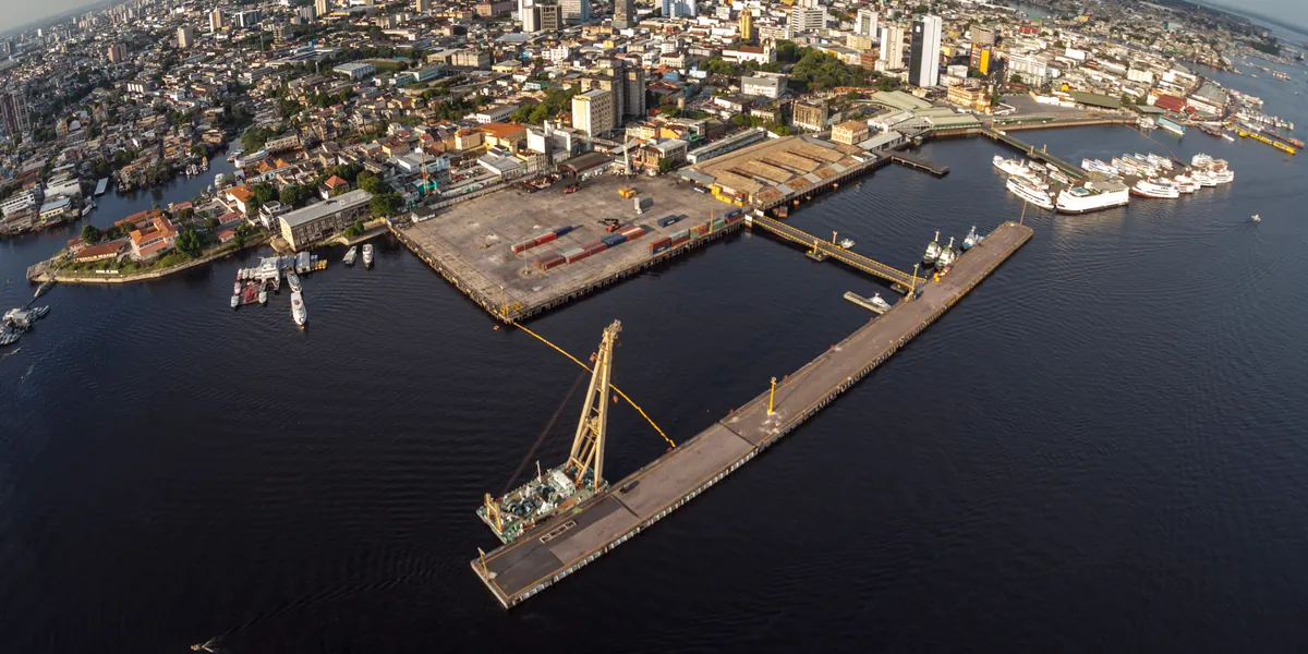
Aerial view of the public Port of Manaus on the Rio Negro, with its floating pier, container yard and passenger vessels along the downtown waterfront.
Port call guide · Amazonas, Brazil

Port of Manaus

Manaus, on the left bank of the Rio Negro in Amazonas, is reached from the Atlantic up the Amazon. Ocean-going cargo ships berth at two private terminals, Porto Chibatão and Super Terminais, which mainly serve Manaus Free Zone imports and exports, while the public port downtown, run by the state agency SNPH, takes cruise ships, ferries and regional craft.

03°09'45.35"S 059°59'22.67"W11

Photo: Porto de Manaus by José Zamith (Portal da Copa), CC BY 3.0 BR. Cropped and darkened by Costa Maritime.

Port of Manaus at a glance

Key facts for planning a call at the Port of Manaus, with numbered sources
Port authority(Autoridade Portuária do porto público (SNPH))

SNPH (Superintendência Estadual de Navegação, Portos e Hidrovias), a State of Amazonas agency, administers the public port (Porto Organizado de Manaus) under Convênio de Delegação nº 01/2019, signed with the Federal Government on 1 Aug 2019 for 25 years. Ocean-going cargo ships berth at private terminals (Chibatão, Super Terminais), which SNPH does not run.1, 2, 3

snph.am.gov.br

Harbour master(Capitania Fluvial da Amazônia Ocidental, NPCF-CFAOC)
  • Capitania Fluvial da Amazônia Ocidental (CFAOC), Manaus, Brazilian Navy.
  • It issues the local rules (NPCF-CFAOC, 3rd modification approved by Portaria nº 163/CFAOC of 29 Sep 2025) and is the Navy authority for pilotage zone ZP-2.
  • Maritime and river emergencies (SALVAMAR): 185.
  • On the way in, the Capitania dos Portos do Amapá (CPAP) is the Navy authority for pilotage zone ZP-1, and its rules (NPCP-AP) set the Barra Norte draft limits.4, 5, 6, 7
Pilotage(Praticagem, Zonas de Praticagem ZP-1 e ZP-2)
  • Manaus lies in pilotage zone ZP-2 (Itacoatiara-Tabatinga), where pilotage is compulsory.
  • The route from the Atlantic crosses ZP-1 (Fazendinha-Itacoatiara), compulsory between parallel 00°03'S off Fazendinha (Amapá) and Itacoatiara, or between Mosqueiro Island (Pará) and Itacoatiara for ships using the straits southwest of Marajó.
  • On the Barra Norte approach, between buoy nº 2 of the Canal Grande do Curuá and that parallel, NORMAM-311 makes pilotage optional, but the Amapá Capitania rules make a pilot compulsory for deeper drafts crossing the Arco Lamoso and the Canal Grande do Curuá, and the Arco Lamoso lies seaward of buoy nº 2 (see maximum permissible draft).
  • Ships that pass Itacoatiara without berthing there or at the Hermasa terminal change pilots off Itacoatiara.
  • By law pilotage is compulsory in pilotage zones for vessels over 500 GT, with exemptions set by the Navy (Lei 9.537/1997, art. 13 §6); NORMAM-311 exempts, among others, Brazilian-flag vessels up to 2,000 GT, foreign-flag vessels up to 500 GT and Brazilian-flag craft classed only for inland navigation.
  • ZP-2 pilots listed by the national pilots' council: PROA (Praticagem dos Rios Ocidentais da Amazônia), Manaus Pilots and Praticagem de Manaus; ZP-1 has 11 listed companies. As of 22 October 2026.4, 8, 9, 7
Maximum permissible draft(Calado máximo (Barra Norte, Passagem do Tabocal e terminais))
  • No fixed figure is published for ocean-going ships at Manaus: two limits apply on the way in, at the Barra Norte and at the Passagem do Tabocal.
  • Barra Norte (Amazon mouth): the Capitania dos Portos do Amapá rules (NPCP-AP, Annex B, item 3) set a maximum draft of 11.70 m for ships crossing the Arco Lamoso and the Canal Grande do Curuá in the current low-water period, or 11.50 m for tankers and ships carrying dangerous cargo. Ships cross the stretch at high water with at least 0.5 m under-keel clearance (1.0 m for tankers and dangerous cargo), may not anchor near it to wait for the tide, and must take a pilot above 11.50 m. The limit is seasonal and higher in the high-water months early in the year.
  • Passagem do Tabocal (Passagem da Costa do Tabocal), on the Amazon between Itacoatiara and Manaus at the upstream end of Ilha das Onças: the draft permitted at this pass limits the draft at the Manaus berths. Depths there are very low for merchant ships in the dry season, which normally runs between September and December, and the figure is set in CFAOC portarias and changes with the river level. The current figure was not confirmed in an official document and is not given; ask the ZP-2 pilots before fixing.
  • At the Chibatão and Super Terminais berths, the CFAOC terminal sheets (NPCF-CFAOC, 3rd modification, 2025) limit the recommended maximum draft to the draft permitted on the critical stretches of the route, with 1.0 m under-keel clearance alongside.
  • At the public port's Cais das Torres, SNPH ties draft and under-keel clearance to the critical stretches, the Barra Norte and a Manaus gauge reading of 16.35 m (sunken pontoon module). Ferries and regional craft at the Roadway and Torres quays: recommended maximum draft (CMR) 2.50 m with 1.00 m under-keel clearance.
  • Fresh (river) water; gauge readings use a local zero, not a chart datum. Obtain the current figure from the ZP-2 pilots before fixing. As of 22 October 2026.1, 2, 6, 7, 10, 11, 12
Maximum vessel size(Navio-tipo (LOA e boca) por terminal)
  • Public port (SNPH), Cais das Torres: reference ship (cruise) LOA up to 294.00 m, beam up to 32.20 m, maximum displacement 44,582 t, which is also the ceiling for the combined displacement of all craft at the quay.
  • SNPH lists 47,998 DWT for international navigation.
  • Design ships in the CFAOC terminal sheets (2025): Chibatão, outer berth LOA 305 m and beam 43.5 m, inner berth LOA 260 m and beam 38 m, with up to three ships alongside at once; Super Terminais, outer berth LOA 305 m and beam 40 m, inner berth LOA 294 m and beam 32 m, with up to two ships at once and never two at the inner berth. As of 22 October 2026.1, 11
River level and tides(Nível do rio Negro (régua do Porto de Manaus) e marés)
  • At Manaus, calls are planned on the seasonal Rio Negro level. Official gauge: Rio Negro at the Porto de Manaus (SGB/ANA station 14990000); readings use a local gauge zero and are not depths.
  • The river usually peaks in June (73% of years) or July (24%), and 91% of annual minima fall in October or November (SGB, 1903-2025 series). Records: 30.02 m on 16 Jun 2021 and 12.13 m on 3 Nov 2024 (SGB).
  • The gauge read 17.12 m on 20 Oct 2026 and was still falling; the SGB bulletin of that day said the level was within the expected range for the period.
  • ANTAQ describes 2023 and 2024 as severe droughts with historically low levels in several Amazon rivers. For 2026 it uses 17.7 m or less on the official Porto de Manaus gauge as the reference for carriers' low-water surcharges, with 30 days' prior notice to ANTAQ.
  • At the river mouth, ships cross the Arco Lamoso at high water (NPCP-AP); tide ranges at the Barra Norte were not verified.10, 13, 14, 7, 15
Berths and terminals(Terminais de Uso Privado (TUP) e porto público)
  • Ocean-going cargo ships use two customs-bonded private terminals (TUPs) on the left bank of the Rio Negro: Porto Chibatão (floating pier 1,110 m by 24 m, with an outer berth of 1,110 m and an inner berth of 960 m; 420,000 TEU a year) and Super Terminais (floating quay 720 m by 24 m; 115,000 m² bonded area), mainly serving Manaus Free Zone imports and exports.
  • The Aurora-EADI dry port is also bonded.
  • The public port downtown (SNPH) has two floating quays, Roadway (253 m) and Cais das Torres (180 m), used by cruise ships, ferries and regional craft, and two fixed quays (Paredão and Plataforma Malcher); its 2025 cargo was general cargo for inland navigation.
  • In September 2026, ANTAQ confirmed special and emergency authorisations for Chibatão and Super Terminais to handle containers by transhipment between ships and barges at floating quays off Itacoatiara, for 180 days (Acórdãos nº 559 and 560/2026/ANTAQ, DOU of 16 Sep 2026).16, 3, 1, 2, 17, 11, 18, 19
Clearance authorities(Receita Federal, ANVISA, Polícia Federal e VIGIAGRO)
  • Customs: Alfândega da Receita Federal no Porto de Manaus.
  • Health: ANVISA, Coordenação de Vigilância em Portos, Aeroportos e Fronteiras - Amazonas (office at Eduardo Gomes airport); free pratique (Certificado de Livre Prática) is requested through Porto Sem Papel at most 48 h and at least 24 h before arrival (72 h where ANVISA works business days only).
  • The CFAOC rules designate Manaus anchorage 2 for vessels in quarantine.
  • Immigration and crew changes: Polícia Federal, Superintendência Regional no Amazonas (DELEMIG for migration; maritime police NEPOM).
  • Agriculture: VIGIAGRO, Serviço de Vigilância Agropecuária Internacional de Manaus (SEV-MAN).3, 20, 21, 6, 22, 23
Crew change airport(Aeroporto Internacional Eduardo Gomes)
  • Manaus, Eduardo Gomes International Airport (IATA MAO, ICAO SBEG), an international public aerodrome run by Concessionária dos Aeroportos da Amazônia (VINCI Airports).
  • The operator lists Azul, GOL, LATAM and Copa Airlines among its carriers.
  • About 16 km by road to the Chibatão and Super Terminais area, roughly 27 minutes without traffic; about 13 km to the downtown public port, roughly 17 minutes (approximate routes on OpenStreetMap data from the AISWEB aerodrome reference point).24, 25, 26, 27
Dredged depth and access channel(Profundidade nos cais)
  • Depth alongside varies with the river level.
  • SNPH gives an available depth of between 25 m and 45 m at the Roadway and Torres floating quays of the public port.
  • No official depth tied to a gauge reading was confirmed for Chibatão or Super Terminais.
  • Depths are not permitted drafts; the draft limits are at the Barra Norte and the Passagem do Tabocal.2, 1
Anchorages(Fundeadouros de Manaus)
  • Manaus anchorages (NPCF-CFAOC, chart DHN 4110): anchorage 1 for general cargo ships waiting to berth; anchorage 2 for vessels in litigation, including quarantine; anchorages 3, 4 and 5 for ships carrying petroleum products waiting to berth or gas-freeing.
  • Anchoring is prohibited in the area that keeps access clear to the Moageira (Trigolar), Super Terminais, Porto de Manaus and Chibatão terminals.
  • Transhipment, when authorised, takes place only in areas set by the Capitania. As of 22 October 2026.6
Restrictions(Restrições à navegação e às manobras)
  • Ships may not proceed up the Amazon from the Fazendinha anchorage (Amapá) unless both radars (S and X band) work; at least one echo sounder must work and charts must be up to date, which the Amapá Capitania checks at the naval inspection at that anchorage (NPCP-AP).
  • In the CFAOC area, speed is limited to 5 kn over the ground within 150 m of the river banks.
  • The CFAOC rules describe the Amazon as navigable all year, with navigation restrictions only in the dry season, which normally runs between September and December; at the Passagem do Tabocal large ships should agree manoeuvres with small craft by VHF (NPCF-CFAOC).
  • The Barra Norte draft limits at the river mouth apply all year (see maximum permissible draft).
  • At Chibatão and Super Terminais (CFAOC terminal sheets, 2025), berthing and unberthing at the outer berths have no time restriction and ships berth starboard side to, while at the inner berths ships berth and unberth in daylight only and berth port side to; ships moving to a berth keep one anchor out of the hawse pipe, above the waterline, ready to let go in an emergency, the 300 m approach corridor must be clear, barge operations at the neighbouring terminals stop during manoeuvres, a Port Master handles communication between terminal and ship during manoeuvres, ships need reinforced bitts and fairleads for a 50 t pull, and ships alongside keep at least 10% of the larger ship's length apart, never under 15 m.
  • At the public port, the cruise design ship at Cais das Torres and all inner-quay manoeuvres are daylight only, and berthing and unberthing at Cais das Torres require VHF-equipped launches suited to handling mooring lines.
  • For the 2026 dry season, Portaria nº 140/2026/CFAOC (22 Sep 2026) requires ships passing the critical points between Manaus and Itacoatiara and between Manaus and Coari, at the places the pilots indicate before or during the passage, to keep both anchors ready to let go, with the boatswain (Mestre do navio) at his station on the bow. As of 22 October 2026.7, 6, 28, 11
Tugs(Rebocadores)
  • CFAOC terminal sheets (NPCF-CFAOC, 3rd modification, 2025): at Chibatão and Super Terminais, at least two azimuth tugs for every berthing and unberthing, and for ships of the design-ship size in conditions close to the sheet's wind, current and visibility limits, the number set in the terminal's real-time manoeuvre simulation reports.
  • In the falling-river season (vazante), tugs at the inner berth stay within 70 m of the quay (ships with beam up to 25 m at Chibatão and 32.20 m at Super Terminais); with the Manaus gauge reading at least 15.29 m, the depth at that limit is about 4.0 m.
  • Public port, Cais das Torres: at least two azimuth tugs, with the power set in the quay's detailed project and real-time simulations.11
Pilot boarding(Pontos de espera de prático)
  • Ships entering through the Barra Norte may take a pilot near buoy nº 2 of the Canal Grande do Curuá (01°13'00"N 049°34'30"W), where NORMAM-311 makes pilotage optional.
  • The Amapá rules make a pilot compulsory for deeper drafts crossing the Arco Lamoso (see maximum permissible draft), and the Arco Lamoso lies seaward of that waiting point, so a ship that needs a pilot there should agree the boarding position with the ZP-1 pilots in advance.
  • Ships from sea take the compulsory ZP-1 pilot off Fazendinha (00°04'00"S 051°06'00"W).
  • Ships coming from Belém or Vila do Conde change pilots at Icoaraci, near Ponta do Pinheiro.
  • Manaus-bound ships that do not berth at Itacoatiara change to a ZP-2 pilot, who boards near the port of Itacoatiara.
  • Request notice was not verified; ask the pilots.4, 9
Weather limits(Visibilidade, vento e corrente)
  • In the dry season, which normally runs between September and December, smoke from fires can restrict visibility on the Amazon, and heavy rain and morning fog can reduce it all year (NPCF-CFAOC).
  • In October 2026 the ZP-2 pilots warned that smoke over Manaus calls for attention to visibility.
  • Limits for berthing and unberthing in the CFAOC terminal sheets (2025): Chibatão, wind up to 15 kn, current up to 1.0 kn at the outer berth and 1.2 kn at the inner berth, visibility at least 2 NM; Super Terminais, wind up to 12 kn, current up to 1.2 kn, visibility at least 2 NM; public port quays, wind up to 15 kn, current up to 2.0 kn, visibility at least 2 NM. As of 22 October 2026.6, 12, 11
Bunkers, fresh water and waste reception(Água, combustível e resíduos)
  • Fresh water: Chibatão supplies 7.5 m³/h, and the public port has potable water and an electricity supply at 380 V, 220 V and 110 V (CFAOC terminal sheets, 2025).
  • At the public port, bunkering by transfer between vessels may only be carried out under NORMAM-204/DPC, Chapter 5, Section I.
  • MARPOL waste reception was not verified.11
Main cargo and throughput(Movimentação de cargas)
  • Public port (SNPH), 2025: 12,352.16 t of general cargo for inland navigation, April-December 2025, with some months pending.
  • Figures for Chibatão and Super Terminais were not confirmed in an official source.17

For planning reference only, not for navigation. Drafts depend on tide, under-keel clearance, ship type and the current port authority and Capitania dos Portos rules; the pilots and the Capitania have the final word. Confirm before fixing the vessel. Our operations desk can obtain the current figure from the pilots.

Planning a call at Manaus

  • Two limits set the draft for Manaus: the Barra Norte at the Amazon mouth, now 11.70 m (11.50 m for tankers and dangerous cargo) and crossed at high water, and the Passagem do Tabocal near Manaus, whose dry-season figure changes with the river; the ZP-2 pilots give the current figure.
  • Plan on the Rio Negro level: it usually peaks in June or July and is lowest in October or November, and for 2026 ANTAQ uses 17.7 m or less on the Manaus gauge as the reference for low-water surcharges.
  • Pilotage is compulsory from Fazendinha and in zone ZP-2, with a pilot change off Itacoatiara; deep-draft ships agree the Barra Norte boarding position with the ZP-1 pilots in advance.
  • In the 2026 dry season ships keep both anchors ready, with the boatswain on the bow, at the critical points between Manaus and Itacoatiara, and ANTAQ has authorised Chibatão and Super Terminais to tranship containers to barges at floating quays off Itacoatiara for 180 days.
  • At Chibatão and Super Terminais the outer berths take design ships of 305 m LOA, every berthing and unberthing needs at least two azimuth tugs, and ships berth and unberth at the inner berths in daylight only.

Before arrival, your agent requests free pratique (Certificado de Livre Prática) through Porto Sem Papel between 48 and 24 hours before arrival and orders the ZP-1 and ZP-2 pilots, agreeing the Barra Norte boarding position for deep-draft ships.

Port of Manaus: frequently asked questions

What is the maximum draft for ships calling at Manaus?

No fixed figure is published for ocean-going ships. Two limits apply on the way in: the Barra Norte at the Amazon mouth, where the Amapá Capitania's rules (NPCP-AP, Annex B) allow 11.70 m in the current low-water period, and the Passagem do Tabocal near Manaus, where the dry-season figure changes with the river level. At Chibatão and Super Terminais the CFAOC terminal sheets (2025) cap the draft at the critical-stretch limit with 1.0 m under the keel. The pilots confirm the draft for each call.

How does the Barra Norte limit drafts to Manaus?

Ships crossing the Arco Lamoso and the Canal Grande do Curuá at the Amazon mouth may draw up to 11.70 m in the current low-water period, or 11.50 m for tankers and dangerous cargo, under the NPCP-AP (Annex B, item 3). They cross at high water with at least 0.5 m under the keel (1.0 m for tankers and dangerous cargo), may not anchor nearby to wait for the tide and take a pilot above 11.50 m. The limit is higher in the high-water months, and the pilots confirm the draft for each call.

How does the dry season affect calls at Manaus?

The Rio Negro is usually lowest in October or November, and the record low on the Manaus gauge is 12.13 m (3 November 2024). In the dry season the Passagem do Tabocal limits drafts to the Manaus berths, Portaria nº 140/2026/CFAOC requires both anchors ready at the critical points between Manaus and Itacoatiara and between Manaus and Coari, and ANTAQ uses 17.7 m on the gauge as the 2026 reference for carriers' low-water surcharges.

Is pilotage compulsory for the Port of Manaus?

Yes. Manaus is in pilotage zone ZP-2, where pilotage is compulsory, and the route from the Atlantic crosses zone ZP-1, compulsory between parallel 00°03'S off Fazendinha and Itacoatiara, where ships change pilots. Between buoy nº 2 of the Canal Grande do Curuá and Fazendinha pilotage is optional, except for deeper drafts crossing the Arco Lamoso.

Where do ocean-going ships berth at Manaus?

At two customs-bonded private terminals on the left bank of the Rio Negro: Porto Chibatão, a 1,110 m floating pier with outer and inner berths, and Super Terminais, a 720 m floating quay. Their outer berths take design ships of 305 m LOA. The public port downtown, run by SNPH, takes cruise ships at Cais das Torres, up to 294 m LOA.

Working with Costa Maritime at Manaus

At Manaus, a vetted local partner attends the vessel on our behalf. You deal only with Costa Maritime: we prepare your PDA and FDA and remain your single point of contact.

Proforma disbursement account (PDA)

Send the vessel type, GT and NT, LOA, beam and drafts, the purpose of the call, the cargo and the expected days in port, and we prepare your proforma disbursement account.

Request a PDA for Manaus

The PDA is an estimate based on the particulars you send and the tariffs and exchange rate in force; the final disbursement account (FDA) reflects the actual call.

Sources

  1. Porto de Manaus - SNPH, SNPH, Governo do Estado do Amazonas. Accessed 21 October 2026.
  2. Regulamento de Gestão e Operação do Porto Público Organizado de Manaus, SNPH, Governo do Estado do Amazonas, 2024 text, signed copy published February 2026. Accessed 21 October 2026.
  3. Alfândega da Receita Federal no Porto de Manaus, Receita Federal. Accessed 21 October 2026.
  4. NORMAM-311/DPC, 2026 edition with Mod. 5 (Portaria DPC/DGN/MB nº 206, 21 Sep 2026); Annexes 4-A and 4-B, Marinha do Brasil, Diretoria de Portos e Costas (DPC), 21 September 2026 (Mod. 5). Accessed 21 October 2026.
  5. Portaria nº 163/CFAOC, de 29 de setembro de 2025 (3ª Modificação das NPCF/CFAOC), DOU 8 Oct 2025, ed. 192, Marinha do Brasil, Capitania Fluvial da Amazônia Ocidental (DOU page on assets.marinha.mil.br), 29 September 2025. Accessed 21 October 2026.
  6. NPCF-CFAOC, 2ª Mod. (Portaria nº 117/CFAOC, 21 Jul 2025); item 6.1.1, Marinha do Brasil, Capitania Fluvial da Amazônia Ocidental (CFAOC), 21 July 2025. Accessed 21 October 2026.
  7. NPCP-AP, 2ª Revisão with Mod. 2, Marinha do Brasil, Capitania dos Portos do Amapá (CPAP), 5 November 2025 (Mod. 2). Accessed 21 October 2026.
  8. Lei nº 14.813, de 15 de janeiro de 2024, publicação original (DOU Seção 1, 16/01/2024, p. 1), Câmara dos Deputados, Legislação Informatizada, 15 January 2024. Accessed 21 October 2026.
  9. Zonas de Praticagem, Praticagem do Brasil (Conselho Nacional de Praticagem). Accessed 21 October 2026.
  10. 42º Boletim de Alerta Hidrológico da Bacia do Amazonas, Serviço Geológico do Brasil (SGB), 20 October 2026. Accessed 21 October 2026.
  11. NPCF-CFAOC, 3ª Modificação (Portaria nº 163/CFAOC, 29 Sep 2025): fichas do TUP Chibatão, do TUP Super Terminais e do Porto Público de Manaus (Cais das Torres e Roadway), no arquivo compactado da página de normas, Marinha do Brasil, Capitania Fluvial da Amazônia Ocidental (CFAOC), 29 September 2025. Accessed 22 October 2026.
  12. Boletim 011/26, Monitoramento da Estiagem 2026, PROA, ZP-2 pilots, 16 October 2026. Accessed 21 October 2026.
  13. ANTAQ reforça controle sobre cobrança da taxa de seca na Região Amazônica, ANTAQ, 15 September 2026 (updated 20 October 2026). Accessed 21 October 2026.
  14. Nível dos rios em 10/2026, PROA, ZP-2 pilots, 20 October 2026. Accessed 21 October 2026.
  15. Comunicações da Diretoria, 616ª Reunião de Diretoria (SEI 2997008), ANTAQ, 14 August 2026. Accessed 21 October 2026.
  16. Infraestrutura - SUFRAMA, SUFRAMA, updated 24 July 2025. Accessed 21 October 2026.
  17. Relatório de Peso (TN) por Mês, ano de referência 2025, SNPH, September 2026. Accessed 21 October 2026.
  18. Acórdão nº 559/2026/ANTAQ (Chibatão Navegação e Comércio Ltda.: transbordo de contêineres entre navios e balsas em cais flutuante ao largo de Itacoatiara, 180 dias), DOU de 16/09/2026, ed. 175, Agência Nacional de Transportes Aquaviários (ANTAQ), no Diário Oficial da União, 16 September 2026. Accessed 22 October 2026.
  19. Acórdão nº 560/2026/ANTAQ (Super Terminais Comércio e Indústria Ltda.: transbordo de contêineres entre navios e balsas em cais flutuante ao largo de Itacoatiara, 180 dias), DOU de 16/09/2026, ed. 175, Agência Nacional de Transportes Aquaviários (ANTAQ), no Diário Oficial da União, 16 September 2026. Accessed 22 October 2026.
  20. Mapa de unidades, Amazonas, ANVISA, published 9 July 2025. Accessed 21 October 2026.
  21. Solicitar Certificado de Livre Prática, ANVISA (gov.br services portal), updated 15 December 2025. Accessed 21 October 2026.
  22. Superintendência e delegacias, Amazonas, Polícia Federal, updated 11 May 2026. Accessed 21 October 2026.
  23. DIGRV-N, Divisão de Gestão Regional do Vigiagro - Norte, Ministério da Agricultura e Pecuária (MAPA), updated 12 January 2026. Accessed 21 October 2026.
  24. AISWEB, aeródromo SBEG, DECEA, ROTAER D-AMDT 24/26. Accessed 21 October 2026.
  25. Manaus Airport, VINCI Airports (airport operator group). Accessed 21 October 2026.
  26. Manaus Airport (home), Concessionária dos Aeroportos da Amazônia (VINCI Airports). Accessed 21 October 2026.
  27. OSRM demo routing, SBEG reference point to Chibatão quay NW end, Project OSRM (OpenStreetMap data). Accessed 21 October 2026.
  28. Portaria nº 00140/2026/CFAOC, de 22 de setembro de 2026 (medidas adicionais de segurança da navegação em virtude do período de estiagem), Marinha do Brasil, Capitania Fluvial da Amazônia Ocidental (CFAOC), 22 September 2026. Accessed 22 October 2026.

Last reviewed: October 2026

Planning a call at Manaus?

Send the vessel particulars and the dates. We prepare the PDA and coordinate the call with one point of contact.